
How far is Miami from the other major cities of the world?
Measuring distances across the planet can be tricky business.
Earth, of course, is a three-dimensional object, a not-quite-so-perfect sphere.
Geographers — and especially practitioners of that even more arcane subject of geodesy — refer to the shape of the Earth as an ellipsoid (or spheroid) to account for its various geometric irregularities. For example, the Earth bulges slightly at the equator, making it wider along its center.
Measuring distances across an irregular three-dimensional surface is not as simple as doing so across a two-dimensional one. Doing it wrong could have grave ramifications.
The most well-known instance that comes to my mind is The Economist’s 2003 mis-representation of the distance North Korean missiles could travel.
![The Economist's Erroneous North Korea Missile Range Map. Original Print: May 3, 2003. Reposted from the ESRI blog [http://blogs.esri.com/].](https://miamigeographic.com/wp-content/uploads/2014/07/northkoreamissilerangemap1.png)
The Economist’s Erroneous North Korea Missile Range Map. Original Print: May 3, 2003. Reposted from the ESRI blog [http://blogs.esri.com/].
Shortly after, The Economist acknowledged its “flat-earth thinking” and issued the following correction:
Flat-earth thinking. Thank you to those readers who pointed out that, by superimposing concentric circles on a Mercator projection, the map [. . .] greatly underestimated the potential reach of North Korea’s missiles. We stand corrected.
The corrected version — which transforms the distance intervals to accommodate the Earth’s three-dimensionality — paints a more geographically-inclusive (and thus much more ominous) picture of North Korea’s intermittent missile threats.
![The Economist's Corrected North Korea Missile Range Map. May, 2003. Reposted from The Economist [http://www.economist.com].](https://miamigeographic.com/wp-content/uploads/2014/07/northkorea_correctedmissilemap.gif)
The Economist’s Corrected North Korea Missile Range Map. May, 2003. Reposted from The Economist [http://www.economist.com].
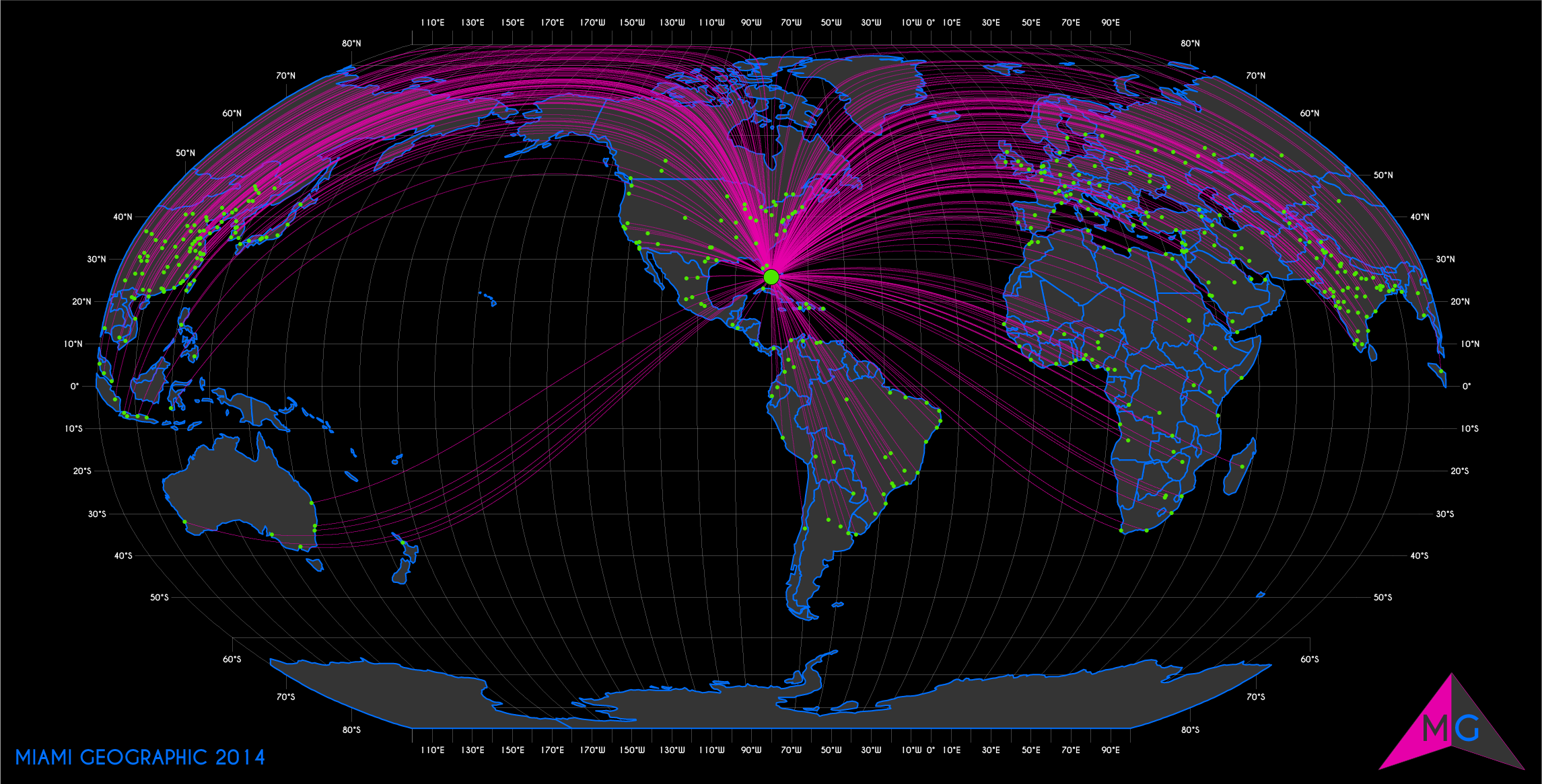
Miami Geodesic Distances to World Cities — Global View. Base Layer Data Source: Natural Earth. 2014. Map Source: Matthew Toro. 2014.
Google Maps recently made City Lab news for adding a geodesic distance measuring tool.
I thought I’d investigate some geodesic distances myself, using other geographic information system (GIS) tools, to elucidate just how far Miami is from other major world cities.
The results are presented by continent.
- North America
- South America
- Europe
- Africa
- Asia
- Oceania (Australia, New Zealand, and Pacific Island sub-regions)
A few methodological and cartographic notes:
- All distances displayed are in kilometers (km).
- All geospatial base layer data came from Natural Earth. For world cities, I used their Populated Places layer. The Admin 0 — Countries were used for the background territories.
- Cities displayed in the maps below include only those containing at least one million (1,000,000) persons. (I did, however, measure distances to a far greater number of cities and towns across the world. If you’re curious about Miami’s distance from a particular settlement not displayed on any map here, let me know in the comments section.)
- Asia has far too many cities containing at least one million people to coherently represent them all in one map. I had to break-up the Asia map into two: Asia (west) and Asia (east). The division between “west” and “east” here is based strictly on whether the shortest distance from Miami is achieved by traversing the globe eastwardly (west Asia), or crossing it westwardly (east Asia).
- The maps are not ‘upside down’, ‘crooked’, or ‘mis-oriented’: the Earth is typically presented with north pointed upward out of socially-constructed convention, not out of any technical necessity. Here’s a great Al Jazeera piece explaining “How the north ended up on top of the map“. These maps are intended to help change one’s perspective of the world, hence the title: “Into Perspective . . .”
Let’s get on with it:
North America
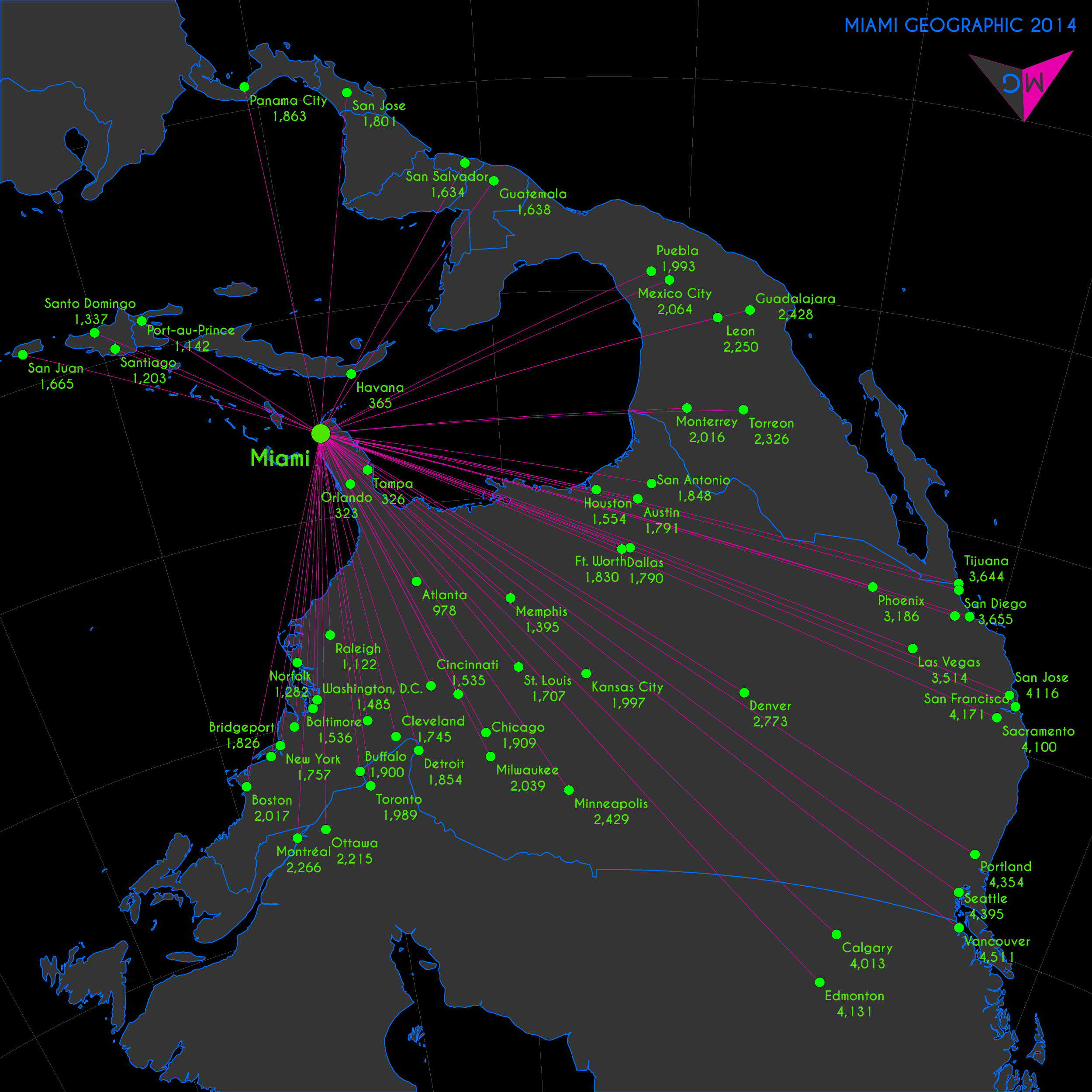
Miami Geodesic Distances (km) to World Cities — North America View. Base Layer Data Source: Natural Earth. 2014. Map Source: Matthew Toro. 2014.
South America
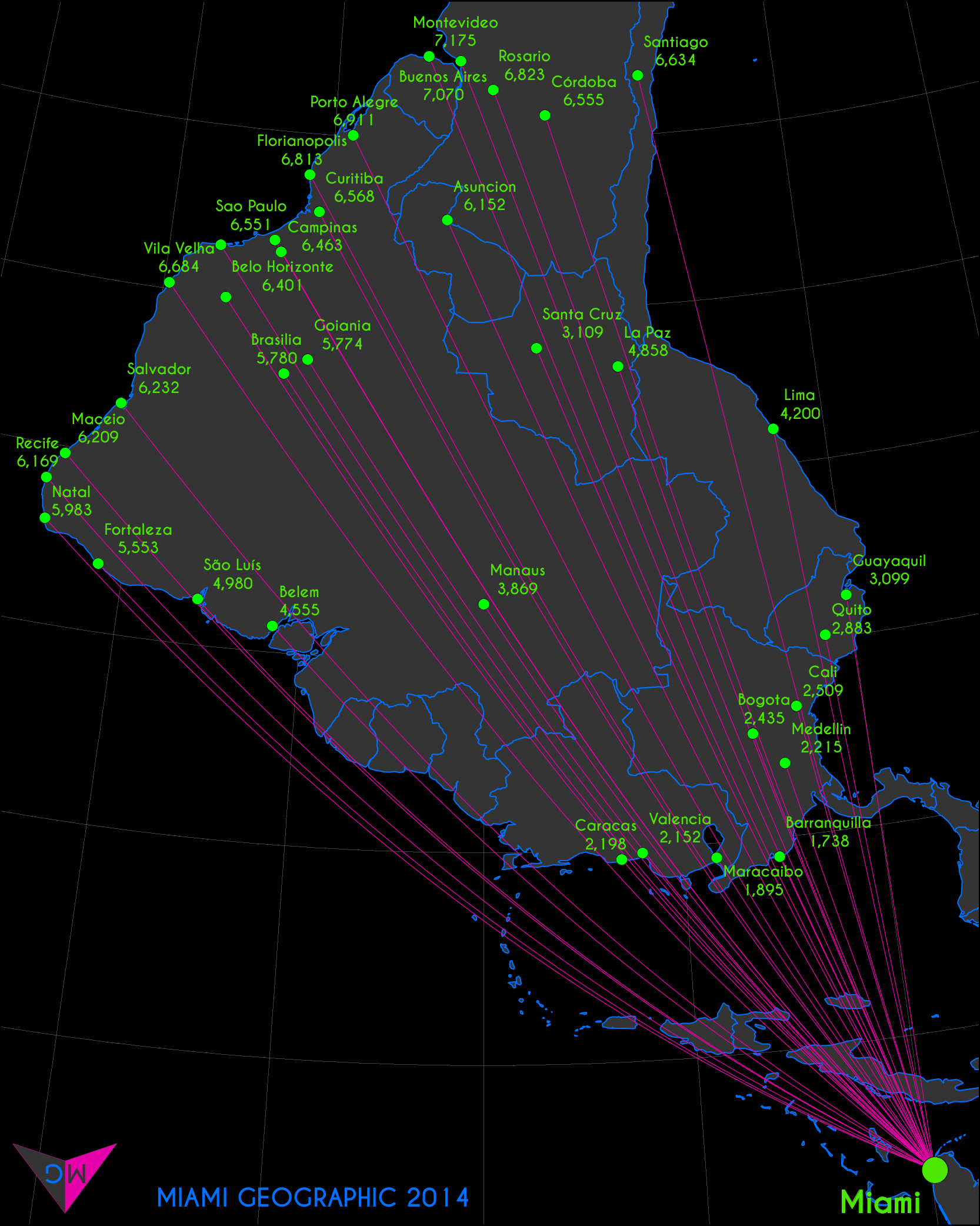
Miami Geodesic Distances (km) to World Cities — South America View. Base Layer Data Source: Natural Earth. 2014. Map Source: Matthew Toro. 2014.
Europe

Miami Geodesic Distances (km) to World Cities — Europe View. Base Layer Data Source: Natural Earth. 2014. Map Source: Matthew Toro. 2014.
Africa
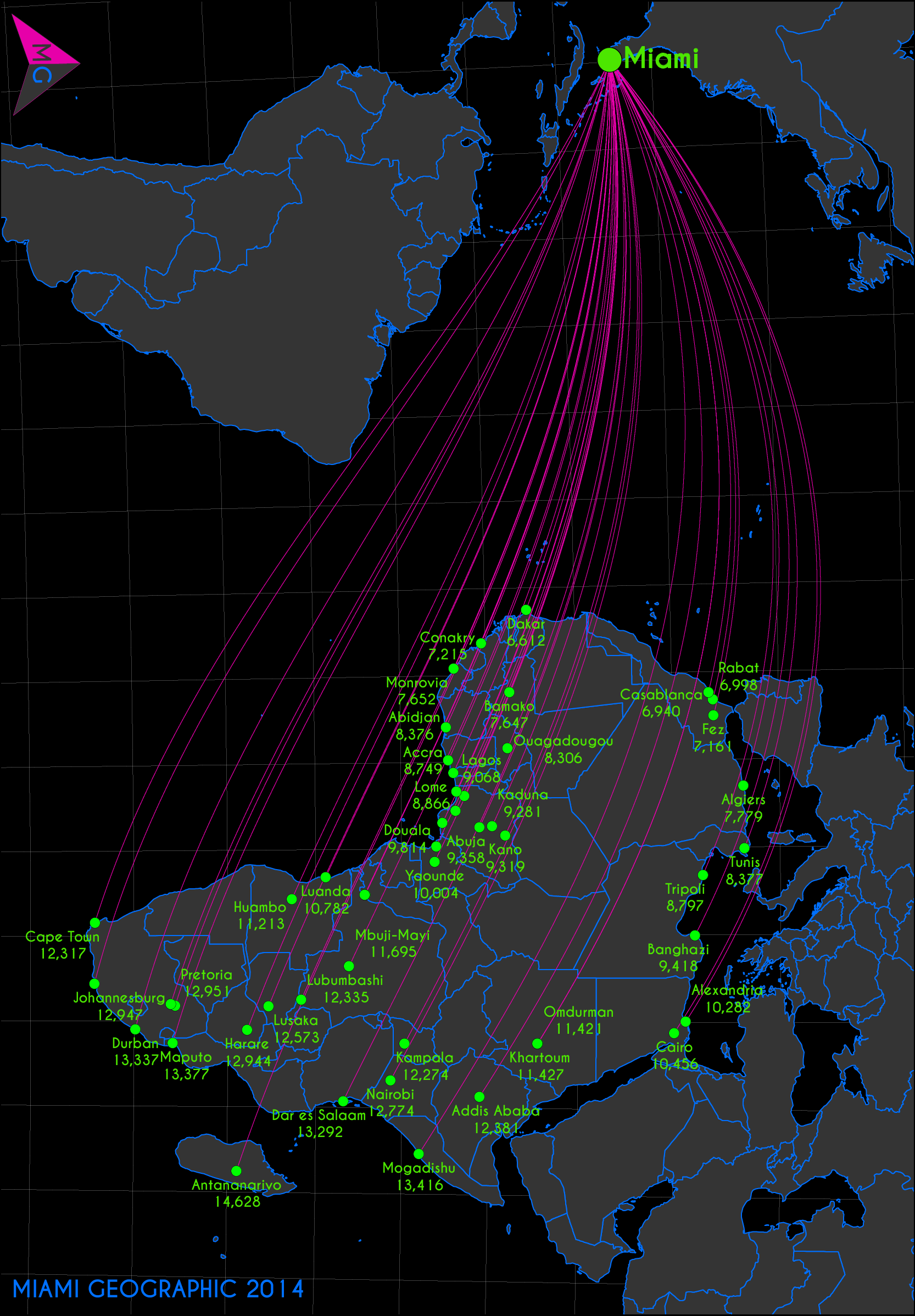
Miami Geodesic Distances (km) to World Cities — Africa View. Base Layer Data Source: Natural Earth. 2014. Map Source: Matthew Toro. 2014.
Asia (west)

Miami Geodesic Distances (km) to World Cities — (West) Asia View. Base Layer Data Source: Natural Earth. 2014. Map Source: Matthew Toro. 2014.
Asia (east)

Miami Geodesic Distances (km) to World Cities — (East) Asia View. Base Layer Data Source: Natural Earth. 2014. Map Source: Matthew Toro. 2014.
Oceania

Miami Geodesic Distances (km) to World Cities — Oceania View. Base Layer Data Source: Natural Earth. 2014. Map Source: Matthew Toro. 2014.
Post-Publication Note (2014/07/26): The distance to San Jose, USA was originally labelled incorrectly; it was originally, and wrongly, labelled as 1801 km. The error was the result of the labeling engine using the distance to San José, Costa Rica, rather than San Jose, USA. The city in California is actually, according to these analyses, 4116 km from Miami. The capital of Costa Rica is 1801 km from Miami. As of July 26, 2014, the corrected map is posted.
(I realize and apologize for the irony in my mapping mistake, as this very piece reports on The Economist’s mapping mistake when depicting potential travel distances of North Korean missiles. As one can see, it’s easy to make errors on maps; just try to limit them to minor labeling errors, and be sure to fix them quickly, or all hell might break loose.)

Veryy nice blog you have here
Really a cool post.I never read about this topic anywhere before this.Its so interesting to see that How far is Miami from the worlds top cities.I am planning my trip to Miami soon and your post really create some interest so i can’t wait to visit Miami now.
Pingback: Miami, the Bellybutton of the Americas, Mapped! - Bragi Sigurdsson·
Huh?
This was a really interesting piece. What I liked the most was how you oriented the maps. At first, it threw me off because I am not used to seeing maps in that fashion. Nevertheless, I think it really adds value and perspective in making your point.
I may be wrong in making this suggestion, but it would be nice to see a part II that compares Miami’s location to Memphis’. The reason why I mention this is because I believe FedEx chose Memphis as their main hub because, geographically, it provides the company with an advantage in serving multiple locations both domestically and internationally. Again, I may be completely wrong with respect to the aforementioned, but since I am biased towards Miami, it would be pretty cool to see how advantageous, if at all, it would be to reach various international destinations when compared to Memphis.
By the way, Memphis should not be the only city to be compared. It would be nice to see various other cities as well.