
https://tramiami.cartodb.com/viz/1196fb1e-f6ce-11e5-8280-0ecd1babdde5/public_map
Have you ever wondered who is responsible for repairing a pothole in the street near your house?
A new interactive map, Who Owns the Road Miami, helps illuminate the patterns and anomalies of street jurisdiction in Miami-Dade County.
The new map used data from Miami-Dade’s open data GIS site imported into CartoDB to render which agencies are responsible for which roadways in Miami-Dade County.
There are a number of interesting features that jump off the page. First is the large number of municipalities in Miami-Dade County. With the demise of the city of Islandia (featured on this map with a single State-owned road, though sadly not Spite Highway) there are 34 different municipalities within Miami-Dade, plus the UMSA, or unicorporated municipal service area.
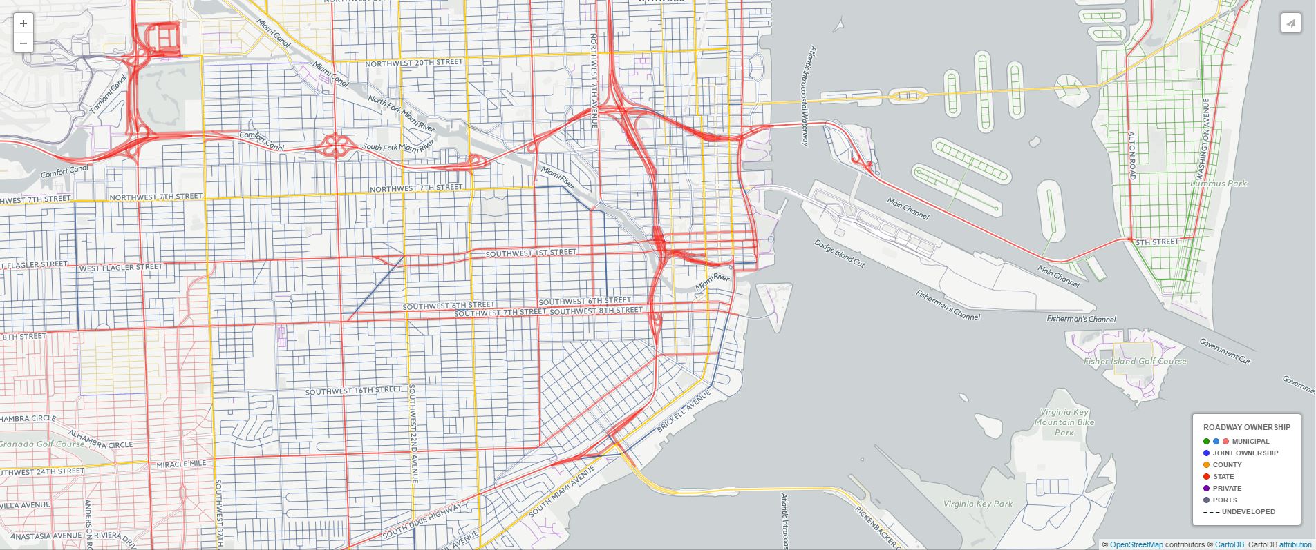
When you figure in state, air- and seaport, and private control of roads, plus undeveloped right-of-ways throughout the county, the network quickly gets messy. Here is a view of downtown Miami showing the tangle of state, county, various municipal, and port-owned roads.
Another interesting thing that I noticed right away was how many of the newer suburban communities have roads that are mostly private. Look at West Kendall, for example (private roads are rendered in purple).

Does this mean that the county will not be responsible for maintaining those roads when it comes time for them to be repaired. If not the county, then who? Do the private residences on those subdivisions collect and save enough tax revenue to completely rebuild their roadways in 30 years?
Some attribution and technical notes:
This map was inspired by Code for America’s Civic Data Alliance (Louisville Brigade) project, Who Owns The Road: Louisville.
Unfortunately, there are several known issues with the data itself:
- MDX Roads are not delineated from State Roads.
- County, State, and National Park roads are marked as private.
- The “lanes” and roadway width data is not accurate.
- The “class” doesn’t seem to match the functional classification standards listed in FDOT’s rules, particularly with regard to the urban/rural split.
There may also be some issues with the way that it is rendered:
- It is possible that some roadways are owned by two municipalities but only one is listed.
This map was created with help from Maptime Miami by Adam Old of TransitAlliance.Miami, a nonprofit which aims to bridge the gaps between citizens, innovators, and government and accelerate the improvement of all aspects of mobility in Miami.

Good morning
as a Miami-Dade public works inspector, I use this map on a daily basis. Is there another way to access due that it has been showing an error message for the the last 5 months. I can be reached at Frank.Cabrera@miamidade.gov
Thanks
Hi Frank, that’s nice to hear that you got some use out of it. Sadly Carto decided to stop hosting it a while ago. The county has a version that is pretty usable now at https://mdc.maps.arcgis.com/apps/webappviewer/index.html?id=c404bf5c81744e778d9c9839949fbd65
The County has one of their own now. https://mdc.maps.arcgis.com/apps/webappviewer/index.html?id=c404bf5c81744e778d9c9839949fbd65
Your link to Who Owns the Road no longer works.
Pingback: Around Houston, a Million People Want to Live in a Walkable Place But Don’t | Streetsblog.net·